What is known as the Tithe Commutation Act map (tithe map) of 1841 and its accompanying book showing tenants, owners etc. for the parish of Armitage-with-Handsacre gives us most of the information we have on old field names although estate maps also provide some information. The different documents do not all agree, and some information was also copied from older documents and could have been out of date. For instance, the tithe map and book show my Gt Gt Gt Gt Grandfather William Scragg living near the Ash Tree and renting land from the Earl Talbot; he had however been buried nine years earlier at Armitage St. John the Baptist church.
Names for fields are more frequently used in speech rather than being written down and are therefore less permanent. Next to Armitage House today are the allotments but it was known as Chantry Wood in the 19th C and then Doctor’s Wood when I grew up in the village in the 1950s and 1960s – the village doctor had lived in Armitage House in the early 1900s.
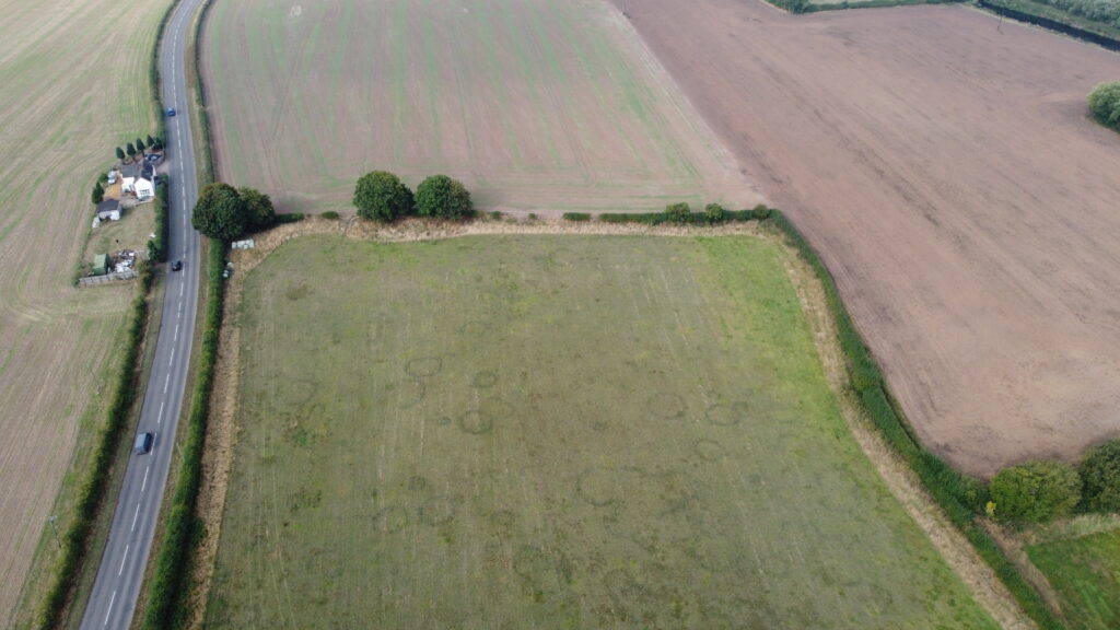
Some of the field names on the tithe map go back hundreds of years and show evidence of what the area looked like just after the Norman conquest and even before. As this drone photo shows there is evidence of neolithic circles near the river in Handsacre and the field name Barrow Lands is derived from the Old English word, beorg meaning a natural or artificial hillock.
In Anglo Saxon times this part of Mercia was a boundary area and the Vikings penetrated deep into the country using the rivers, leaving behind some indications of their presence in the field names. The area by the river has names like Hempholme field, Sweetholme Bank and Far Nettleholme – ‘holmr’ is an Old Norse word for a water meadow or piece of riverside land.
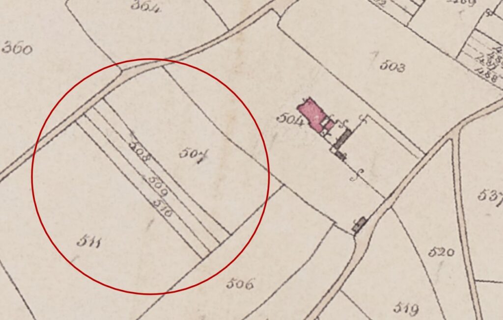
Handsacre Hall was the heart of the manor in the period just after the Norman conquest with all the inhabitants clustered around it. Areas across central England at this time had developed a communal farming layout known as the ‘Midland’ open field system. The system varied from place to place and featured 2 or 3 ‘great fields’ with about ⅓ set aside each year as fallow for common grazing. Each ‘great field’ was split into furlongs which at that time simply meant the length of a furrow rather than a specific length and the strips were distributed between the Lord of the Manor, the church and the rest of the people. These small strips were still partially evident in the tithe map as shown below and were often called Flatts hence Near and Far Lady Flatts.
The field names show that one of these ‘great fields’ was the West Field and the tithe map includes Near, Middle and Far West Field. Next to West Field is the highest point of the manor with the fanciful name of Haven Field, a derivation of Heaven. Beyond that still is the furthest point cultivated at that time – Townsend Leasow – which is the field that was down Boat House Lane, opposite the Swan. Until Hawkesyard was given as a sub-manor to the Ruggeley family in the 1200s this was as far as the arable area of the manor stretched. Even within this arable area though there were parts that were too poor to be cultivated within what was a subsistence farming system. These poor areas generally stretched through boggy areas around the streams and were often called a moor e.g. Westerton Moor, Westfield Moor or Mill Moor but one area was simply known as Toad Hole.

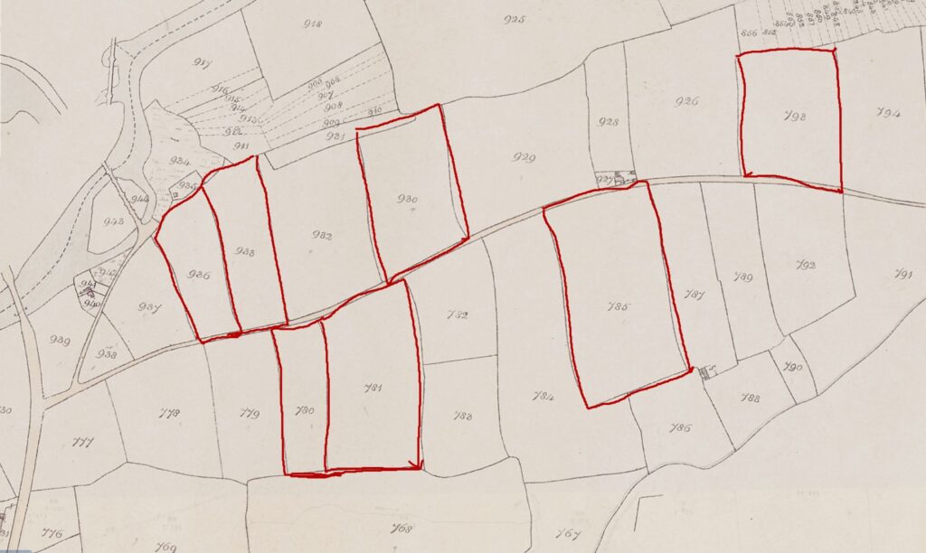
There is not another obvious candidate for being one of the ‘great fields’. Possibly there was a ‘home’ field around the Hall and there may have been another ‘great field’ down by the river called the Mill Field. This part of the tithe map shows a number of fields (outlined in red below) near the river with a mill name e.g. Big Mill Field or Little Mill Field and it is easy to picture the whole area, now bisected by Kings Bromley Lane, as one large field. The exact location of this mill, (the second built in the Manor), by the river is not known but it is believed to have been burnt down in the late 1300s.
There are other field names that denote crops, animals or farm work. Apart from Apple Tree Piece, Crab Tree Flatt, Elder Tree Piece, Oak Tree Leasow, Orchard and Yew Tree Piece there are:
- Cabbage Field
- Flax Meadow – flax is also known as linseed and would have been used to make linen as well as linseed oil
- Big and Little Linfield – another area for growing flax
- Rye Grass Leasow
- Gorsey Close – an area where gorse grew and was harvested for fuel
- Whins Moors – whin is another name for gorse
- Pinfold – manorial courts appointed a pinder, a paid position, who had the duty to round up stray animals and keep them in the pinfold until their owners had paid a fine.
- Ox pasture – oxen are male, castrated, cattle that were fully grown i.e. at least four years old and were used as draught animals e.g. ploughing or carting, until the 1700s when they were replaced by horses
- Cow Close
- Calves Croft
- Long Horse Leys
- Four Day Math – this field will have taken four days for one man to mow
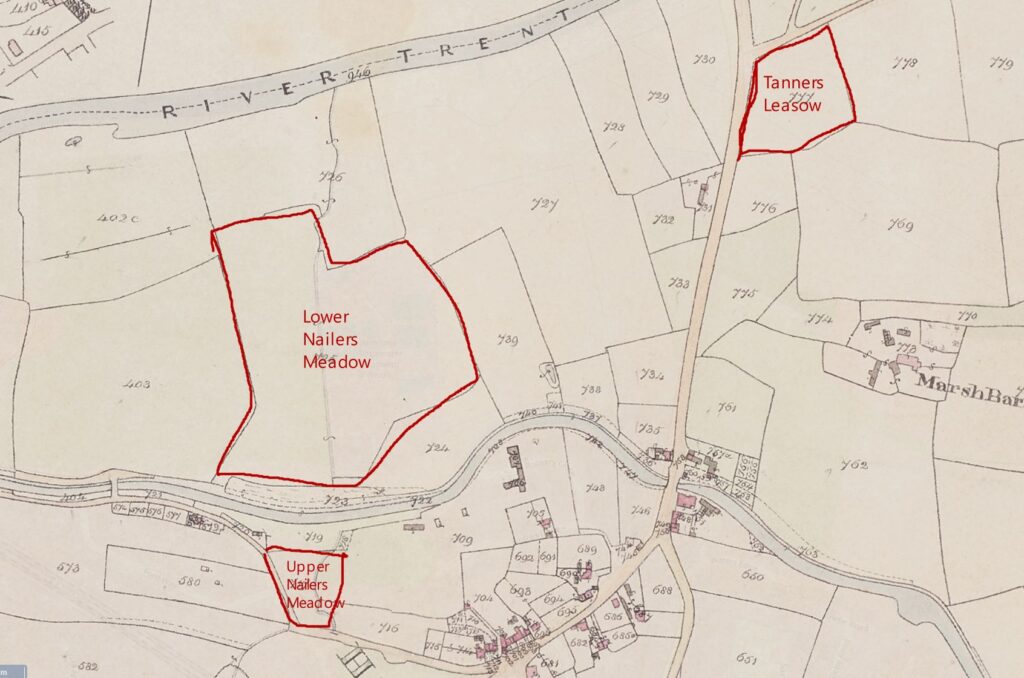
The location of some early industry can also be located as shown by two fields named Upper and Lower Nailers Meadow and a Tanners Leasow. The two Nailers fields are now split by the canal and the second is also named Brook’s Croft, presumably reflecting the demise of nail making in that area. Similarly the tithe map shows Tanners Leasow as also being called ‘Near Roberts Piece’.
There are various names used in many other villages that reflect the shape, size or location of the field:
- Slang – there are eight fields with this as part of the name, including Slang Bottoms. The term denotes a small, narrow strip of land.
- Roundabout – a streamside meadow
- Three Nooks – a triangular piece of land. There is also Three Cornered Piece which for some reason is not called Three Nooks.
- Rail piece – land enclosed with a rail fence
- Intake – land taken in and enclosed
- Pleck – small plot of ground
- Bits – a very small piece of land. (But much bigger than Pleck).
- The Riddings – a clearing
A lot of fields have names attached to them e.g. Alldritts Croft giving an indication of people who have been associated with the village over the centuries. The tithe map shows Adie, Baggerley, Bagnall, Bannister, Barden, Barnett, Carthy, Dunn, Ford, Grimes, Handley, Marshall, Oldacre, Parker, Parr, and Sutton.
Some names still defy explanation, reminding us that even today the landscape continues to hold secrets waiting to be uncovered. Where does Thoughtley come from? Or Willock? Or Thrusty Wake? If you are interested in a particular farm or field please get in touch.