
The Hall Rediscovered
For more than three centuries, the original Hawkesyard Hall stood on low ground beside the River Trent, about half a mile west of St John the Baptist Church in Armitage. It was the medieval home of the Rugeley family and the centre of an estate that shaped this part of the parish long before Nathaniel Lister built the present Hawkesyard House in the eighteenth century.
Today, nothing remains of the original building. Its site lies beneath the cooling lake created during the construction of Rugeley Power Station in the 1960s. Yet, by combining eighteenth-century descriptions, twentieth-century investigations and modern archaeological records, it is possible to reconstruct a surprisingly detailed picture of this long-lost house.
A Moated House
Stebbing Shaw visited the site in the late eighteenth century, when traces of the house were still clearly visible. He described it as standing about half a mile west of Armitage Church, in low, level ground close to the River Trent. He remarked that such a damp location seemed unattractive to eighteenth-century eyes.
The Hall stood within a broad rectangular moat, approximately twelve yards wide. Although moats had once served defensive purposes, by the fourteenth century they had become fashionable features of many gentry houses. At Hawkesyard the broad water-filled enclosure was almost certainly intended to demonstrate wealth and status rather than provide serious military protection. Like the house itself, it proclaimed the standing of the Rugeley family within the parish.
Within the moat stood a substantial square house measuring about 34 yards on each side. Opposite the bridge leading across the moat was a separate area which Shaw thought had probably contained the stables, while nearby lay a large fishpond covering perhaps eight or ten acres.
To the east, between two streams, he traced the remains of a formal walk. From here visitors looked towards the tower of Armitage Church, whilst Cannock Chase formed a distant backdrop. Even in its ruined state, Shaw could still appreciate that the landscape had been deliberately planned.
Only Ruins Remained
By the time Stebbing Shaw visited in the 1790s, only ruins remained. He recorded scattered foundations overgrown with thorn and briars, while foxes sheltered among the ruins. Local tradition still remembered that this had once been the residence of the lords of Hawkesyard and that the last member of the Rugeley family had left the house in a magnificent heraldic funeral procession.
He also noted old apple and plum stocks, remnants of what had once been the manor orchard.
During the nineteenth century the visible remains gradually faded. By the middle of the twentieth century the exact position of the Hall had become uncertain.
Rediscovering Hawkesyard
Fortunately, the story did not end there.
Writing in the 1950s, local historian W. G. Wright described how the site was unexpectedly rediscovered during agricultural work. Around 1930, land beyond Hawkesyard Lane was ploughed for the first time. The plough repeatedly struck heavy sandstone beneath the surface, revealing the foundations of a substantial building. When the crop emerged, the outline of a large rectangle could clearly be seen where the buried walls lay.
An even more significant discovery followed in January 1950, when deep tractor ploughing brought parts of the actual foundations to the surface. Wright recorded walls approximately four feet thick, while the lighter coloured subsoil revealed the full extent of the building platform. The surrounding moat also reappeared as a broad rectangular depression, closely matching Stebbing Shaw’s measurements made more than 150 years earlier.
Wright carefully measured the site, identifying the foundations of the house as approximately 36 yards square. He also recorded the remains of two smaller buildings outside the moat together with the surviving earthworks, allowing the position of the medieval manor to be mapped with considerable confidence.
Lost Beneath the Water
Sadly, the rediscovery came only a few years before the site disappeared forever.
During the construction of Rugeley Power Station in the 1960s, the cooling lake was created over the area occupied by the medieval building. The remaining earthworks and foundations were destroyed, although aerial photographs taken shortly beforehand recorded the outline of the moat, and these observations have since been incorporated into the Historic England record. The moat enclosed an area approximately 32 by 37 metres, remarkably close to the dimensions recorded by both Shaw and Wright.
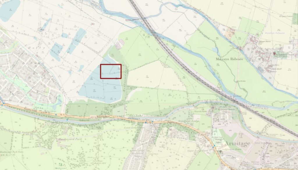
Although the Hall itself has vanished, the documentary evidence, archaeological observations and modern surveys together allow us to reconstruct both its appearance and its setting with unusual confidence.
More Than a Lost Building
The original Hawkesyard was the home of a prosperous gentry family. Surrounded by its moat, fishpond, orchard and formal walks, it formed the centre of a substantial agricultural estate and remained the residence of successive generations of the Rugeleys for more than three centuries.
When the family eventually sold the estate and moved away, the hall lost the people whose history it represented. Over time the buildings disappeared, the site was forgotten and Hawkesyard itself became associated with Nathaniel Lister’s eighteenth-century house rather than the medieval manor beside the Trent.
Ironically, just as twentieth-century historians and archaeologists were beginning to rediscover the original Hawkesyard through documentary research and field investigation, the construction of Rugeley Power Station swept away the last visible traces beneath the cooling lake.
Today, nothing survives above ground. Yet the evidence left by Stebbing Shaw, W. G. Wright, aerial photography and modern archaeological records allows us to recover the story of the place with remarkable confidence. The medieval hall may have vanished, but it remains the starting point of Hawkesyard’s history.